The Rajang River, Sarawak


Rajang River is a river where locate in Sarawak, northwest Borneo, Malaysia. The Iran Mountains is the origin of the river, flows through Kapit, and then towards the South China Sea. It has an approximately length of 560 km long or 351 mile. It is located about 122.4 km that take almost 2 hours 2 minutes drive from Sibu City via Jalan Kanowit. Some of tributary of Rajang River that involved Sungai Balui and Batang Baleh.


As the river is the seventh-longest in Borneo and the longest in Malaysia, the river systems which acts a significant part in sociology and economy development.The steady water supply, hydroelectric power, irrigation and rich soil are the mainly contribute by the river. Rajang River is created as the most diverse diversity in Malaysia. Some of the aquatic flora and fauna in this mighty river had not be exploring by the scientist before.


As of 2015, Bakun Dam is the biggest embankment dam in Southeast Asia with height 205 m (673 ft) and length 750 m (2,461 ft) that locate on the narrow Bakun Fall of Sungai Balui about 37 km upstream of Belaga Town in the State of Sarawak, Malaysia..2,400 megawatts (MW) of electricity will be generating once completed. Along the major rivers and tributaries of Batang Rajan, 534 longhouses is located. The local transportation in the division are served by these rivers.Water quality degradation is increase and happenend by the heavy usage of the river and human activities in the watershed.


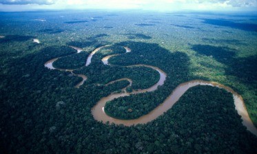
On 4th December 2022, I had the flight from Miri to Kuching for continuing my Agrotechnology degree in University Malaysia Sarawak. During the trip from Miri to Kuching, I had observe the panoramic, impressive and pretty sight aerial view was under the airplane when across the area of state of Sibu. I exclaimed the art of Mother Nature. The composition of the rivers stream tributes in the dendrite branches form typed of creeks or small rives towards to the South China Sea. The topography of delta are presenting in Rajang River due to the rivers empty the river bank and the sediment flows into another river bank, as the time passed the sediment accumulate to form a small area on the lower stream of river, the area get bigger simultaneously through time and the deprived upper stream sediment.
After I arrived to Kuching and back to my university, I had wonder the formation of the creature of Rajang River, the problem they had facing now in Rajang River nowadays is investigated at the same time.


The locals is deprived the sustain of the source of income and protein as the indegionus fishes died due to the human activites. There are many trees are growing beside the river. This provided the convenient location for the logging activities transport the log by replacing into the river after chopping off. This take the good opportunity to transport the logs from the upper stream to lower stream of river.
In conclusion, the formation of the creature of Rajang River and the problem they had facing now in Rajang River nowadays is identified. Human activities leads a lot of the impacts to the ecosystem and the life. Public should be awareness this global warming by doing the actions to lower down the speed of the global warming.