1. Introduction
From the second post-war period, depopulation and marginalization of a considerable number of rural areas in many European countries have progressively intensified with social and economic consequences. This phenomenon is partly due to population growth and progressive urbanization, which in 2007 led the urban population to surpass the rural one and, according to ONU forecasts, will bring more than 68% of people to live in cities in 2050 [
1]. These issues are becoming increasingly significant and endangering the tangible and intangible local culture directly to the point of risking its disappearance [
2]. This problem affects large portions of the national territories, especially in the Mediterranean countries where the population is harmoniously distributed in vast and complex clusters of small municipalities, most of them characterized by an ancient origin settlement still preserved despite the strong seismicity of the area.
Retrieving the specific dynamics of this phenomenon at the local level is complex because there could be multiple causes in economic, social, and psychological terms. In Italy, internal demographic movements have always been important and have involved different scales: a regional one with the population of rural areas moving to the major urban centers, and a national one directed toward the large industrial cities [
3]. This phenomenon has continued to the present day and is, however, attributable to the process of increasing polarization between major urban centers and surrounding inner rural areas, generated by the more significant opportunities offered in terms of university education, job offerings, higher wages, transportation, services, etc. [
4]. Furthermore, youth emigration acts in a twofold way on the depopulation of inland areas: on the one hand, it makes the ageing of the population an even more rapid phenomenon than in the rest of the territory, and on the other hand, the demographic base necessary for the survival of the few commercial and tertiary activities could be lacking, thus aggravating the economic difficulties and social disadvantage [
5].
The presence of 7904 municipalities characterizes the Italian territory; the vast majority of them, about 69.9%, are small or very small, not exceeding 5000 inhabitants but occupying a total of 54.5% of the area. From a demographic point of view, these municipalities represent about 16.5% of the population, just under 10 million. In contrast, the vast majority, about 68.2% of the total, reside in medium-sized municipalities between 5000 and 250,000 habitants. The remainder, 15.3%, live in large cities with more than 250,000 inhabitants [
6]. A total of 2430 among the 5627 municipalities with fewer than 5000 inhabitants, mainly situated in the “inner areas” in the central and southern regions, suffer from progressive depopulation. This demographic decline is accompanied by (i) an evident gap in declared income per capita; (ii) employment rates among youth and adults markedly lower than national rates; (iii) a meagre percentage of the population under 14 years of age; (iv) low percentage of the foreign origin population, highlighting the low attractiveness of places [
7].
Consequently, in recent years, many measures have been taken to preserve and promote these territories, which are little known but are extremely rich in natural, cultural, and architectural heritage. Many of these villages have been included in the list of
Borghi, whose “preservation and enhancement are great importance factors for the Country System as they represent authenticity, uniqueness and beauty as distinctive elements of the Italian offer. Tourism development in these destinations is a decisive lever of economic growth and new employment” [
8]. In this perspective, local governments play a key leading role in the adoption of territorial development policies and strategies, having the opportunity to intercept and make the best use of European structural and investment funds, such as ERDF (European Regional Development Fund), ESF+ (European Social Fund Plus), EAFRD (European Agricultural Fund for Rural Development), and EMFAF (European Maritime, Fisheries and Aquaculture Fund).
The urgent need for government actions is also confirmed by the employment of several national measures: in the 2014–2020 period, the National Strategy for Inner Areas (SNAI) focused on 72 inner areas comprising 1060 municipalities characterized by a lack of services. The plan is structured with the dual purposes of improving health, school, and mobility services and promoting development projects to enhance the inner areas’ natural and cultural heritage [
9]. Another funding is the so-called “save villages law” (
Legge Salva Borghi) No. 158 of 6 October 2017, which involved a total allocation of EUR 160 million by the Italian government to be used in the period 2017–2023. The funding aims are to promote historic centers of small villages in a state of abandonment through renovation and maintenance interventions on the built heritage, school buildings, roads, and other infrastructure, as well as support for productive activities [
10]. Finally, the most recent funding allocated at the national level is the
Borghi National Plan (
Piano Nazionale Borghi) provided by the National Recovery and Resilience Plan (PNRR). It involves revitalizing 250 villages through the settlement of new functions, infrastructure, and services in the fields of culture, tourism, social, or research; other funds are added to support micro, small, or medium-sized enterprises [
11]. Furthermore, the presence of national programs is backed up by the increasing spread of local initiatives to improve the natural and cultural local heritage. For instance, many municipalities have undertaken initiatives to offer benefits to future residents, such as economic incentives, discount sales, etc.
The growth capacity in these rural contexts nowadays depends on their adaptability in seeking innovative development strategies that overcome the center–periphery model [
12]. In recent years, nature tourism has become strongly developed in Italy, representing 32.10% of the destinations reached in 2019 [
13]. This type of travel is mainly chosen by young people, consisting of more than 75% of people from Generation X and Y who appreciate the authenticity of natural environments and are interested in food, wine, and landscape experiences. The relationship between young generations and tourism has been largely explored in the literature [
14,
15]. In this regard, nature-oriented tourism represents a key path to revitalize these mid-mountain areas, while digital technologies represent an indispensable tool to broaden small communities’ territorial heritage awareness and take this out into the wider world. Indeed, nature-oriented tourism in rural areas stimulates new socioeconomic opportunities related to leisure, gastronomy, biodiversity conservation, hospitality, wellness, sports, cultural and architectural heritage enhancement, etc. [
16], and the reinterpretation of traditional activities in terms of tourism, such as agriculture, gastronomy, handicrafts, etc. [
17,
18]. The definition of rural tourism is not unique; rather, this is deliberately broad to embrace all those activities based on sustainable development and respect for environmental resources [
19]. These types of experiences aim to detach the tourist from the stressful rhythms of daily life to awaken them in an authentic setting in harmony with nature [
20,
21]. For this reason, an increasing number of people prefer rural tourism over traditional tourism in order to learn about local communities and traditions, consume organic products, integrate into nature, and build an eco-friendly lifestyle [
22]. These types of activities in rural environments achieve a twofold goal, on the one hand, becoming an effective source of income and jobs, and on the other hand, allowing the active population to remain locally, thus reducing the average age [
23]. The synergy between cultural heritage and tourism has been extensively studied [
24] since it constitutes one of the most important economic development possibilities for small villages, albeit presenting, at the same time, a challenge in management and maintenance arising from seeking the combination of preservation and protection of the cultural asset with its utilization [
25,
26]. Its attractiveness is strongly connected to the picturesque beauty of the scenery, the historical period of its construction, and the authentic identity bond with the places where it is located [
27]. In addition, outdoor activities, such as hiking or cycling, contribute to rural development and help to manage the low season [
28,
29].
Other models aim to achieve a virtuous connection between tourism and territory, involving different sectors: in tourist accommodation, the concept of the
Albergo Diffuso can be mentioned as an innovative model for small villages. The model’s purpose is the respectful integration of the accommodation needs into the historical urban tissue, aiming to reuse available properties instead of building new large structures in disharmony with the context [
30]; on a similar perspective, the
Comunità Ospitali initiative, a project cofinanced by the Ministry of Culture, has identified 27 project partner villages on the Italian national territory in order to develop a new model of sustainable tourism that places the focus on a vacation experience founded on the cultural identity and relationship with local inhabitants. The participation and involvement of citizens are central to this project. Indeed, the experiential dimension is based on the engagement of tourists in typical local activities such as discovering handicraft production, visits to cultural heritage, events related to regional food and wine, etc. [
31]. The
Fondiaria Association offers a slightly different model in Italy, which aims to propose collaboration among small landowners in order to develop new agricultural activities by sharing small properties that would otherwise lie fallow [
32].
In order to develop rural tourism, making effective use of resources is crucial. Still, much will also depend on the local and temporal context, political commitment, the presence of cultural and socioeconomic assets [
33], and stakeholder engagement, often with competing interests [
34]. Furthermore, the attractiveness of a single village is often not enough to establish an adequate touristic offer to base a local economic development. Precisely, in this perspective, it is crucial to strengthen and develop understanding and cooperation between neighboring realities with similar interests in order to increase the proposed offer and, consequently, the scale of the attractiveness of places [
35] as well as the presence of sufficiently maintained mobility and being easily connected with contiguous cities [
36]. However, nowadays, along with physical connections, the possibility of employing linkups and virtual solutions is equally essential in order to promote and publicize the place, creating a collective imaginary of the village. For this purpose, photography and the dissemination of images through social networks are central to attracting new tourists [
37]. Several studies have tried to analyze what factors drive hikers when choosing their routes. Some point to the need to find a place of introspection and mental hygiene [
38], while others attribute the importance to having a significant number of attractors with landscape value [
39,
40]. However, it would be fair to consider how the choice is mediated by these and other factors, such as hiking trail surface, trail conditions, presence of physical limits, elevation gradient, the attractiveness of the environment, etc. [
41]. The literature shows how a low challenging environment such as a hilly or lowland landscape that provides short hikes is more attractive, overcoming physical and age limits [
41].
The use of digital technologies should have an empowering impact on tourism development from two perspectives: (i) first, the design of GIS-based interactive maps allows to integrate the heterogeneous data sources into a unique decision-support tool to understand the geospatial relations between elements. Consequently, cartographic visualization of thematic data became an immediate way of understanding and guiding territorial intervention strategies [
42]. Numerous researchers have tried to study the application of multicriterial methodologies to provide a reliable site overview aimed at improving tourist potential and indicating a selection of priorities in the managing process [
43,
44,
45]; (ii) the increasing influence and growing use of smartphone tourism purposes applications contribute to the global visibility of places to a large number of users. In this regard, the contents of tourist maps should be attractive and provide intuitive, reactive, and engaging information.
The trend of tourist presence in Italy was particularly affected by the two economic crises that reduced purchases between 2008/2009 and 2021/2013 and, above all, the consequent crisis from the COVID-19 epidemic. In the five years from 2015–2019, the recovery occurred evenly from north to south, with an increase of more than 3% per year [
46]. On the other hand, the COVID-19 epidemic emergency led to the travel ban, causing in Italy a drop in presence in accommodation structures of around 57.6 per cent between the years 2019/2020 and an increase of only 41.2 per cent between 2020 and 2021. However, the increase was insufficient to bring values back to precrisis levels, as the overall percentage change in 2019/2021 was −40.1% [
47]. Concerning the Abruzzo region, the trend differs from the national one: in the five years from 2015–2019, it had a late and bland recovery of only 0.8% [
46], insufficient to reach precrisis values; in the two-year post-pandemic period, the 2019/2020 percentage change was much smaller, −34.9%; the 2020/2021 percentage change was +24.4%, and overall the drop was only 19.0% [
47]. With regard to the distribution between the different tourist destinations in Abruzzo in the period 2008–2019, the main cities moved from 29.7% to 25.6%, mountain locations from 10.9% to 7.8%, seaside locations from 57.8% to 64.4%, and hillside locations from 1.6% to 2.2%, fully mirroring the national trend [
46].
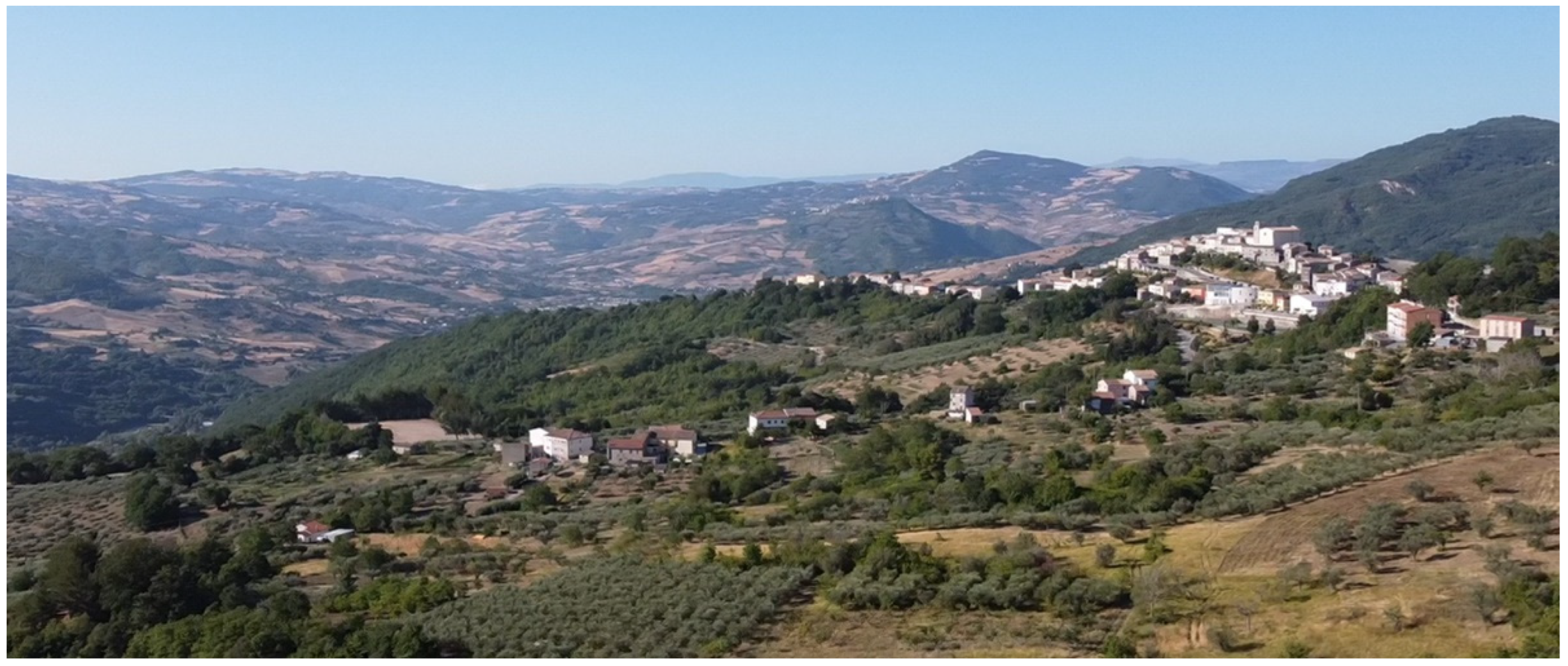
San Giovanni Lipioni (
Figure 1) is a small historic village, only 8.82 square kilometers in size, located in the province of Chieti on a mountain ridge at 545 m above sea level near the valley of the Trigno River that separates Abruzzo from Molise and is included in the Basso Sangro Trigno inner area. Recurring typological, architectural, and constructional features of historic villages in the inland areas of central and southern Italy are present, characterized by very compact building aggregates with complex and highly irregular volumes, narrow streets with rare open clearings, and a strong fragmentation of property [
48]. Since the second half of the twentieth century, the village has suffered gradual depopulation due to the demand for the labor required by the development of the automotive industry in the region’s main coastal centers [
49]. In particular, from 1971 to the present, the village has lost more than 70% of its population, decreasing to only 149 inhabitants with a very high average age of 72 years, according to the latest 2021 census data [
50]. The age distribution is as follows: 0 to 15 years, 2.0%; 15 to 30 years, 3.3%; 30 to 67 years, 39.7%; over 67 years, 55.0%. Inevitably, this demographic trend has affected the built heritage conservation and the reduction of business activities. Indeed, only 15% of the housing stock is permanently occupied, 58% is inhabited during the summer when many people return to their native village, and 28% is unused [
51]. Only a few commercial activities are still open in the area; there is a pharmacy, a doctor’s office, a bar, and a small grocery store. Consequently, these data highlight the need for urgent actions in order to preserve the village and the territory, preventing complete abandonment.
2. Materials and Methods
The present paper aims to describe how digital tools can be used to analyze and map the natural heritage and ancient footpaths and create a territorial trail system between the small municipalities near San Giovanni Lipioni as an economic, social, and tourist development strategy.
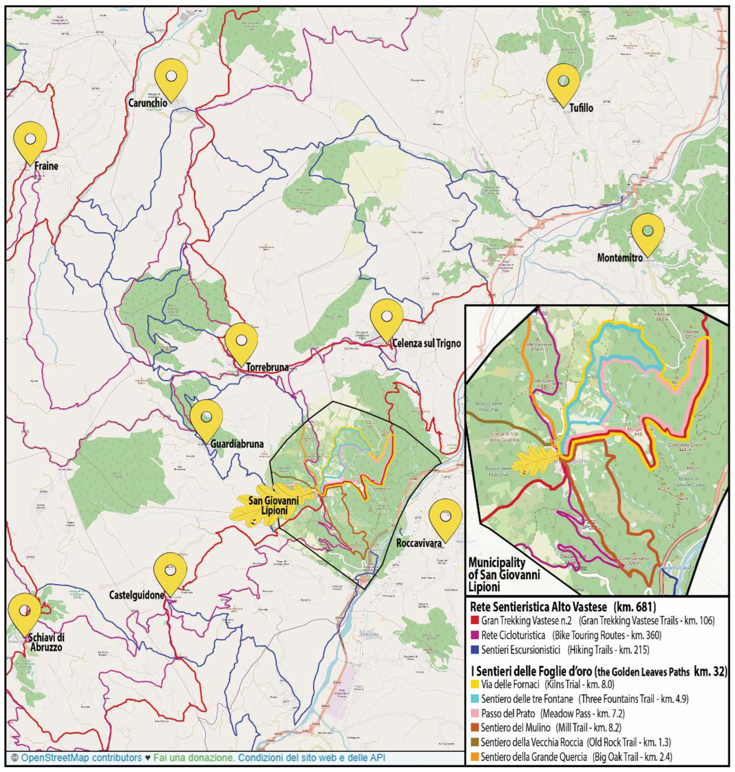
As a matter of fact, the surrounding area is characterized by the presence of towns and villages of similar size, conformation, and needs, connected by a dense network of dirt roads used until a few decades ago for agriculture and pastoralism. Nowadays, most of these dirt trails are still usable and need little maintenance, while a small portion of less frequented roads needs to be mapped and brought back to light. This large-scale refunctionalization project of the ancient trail system is called
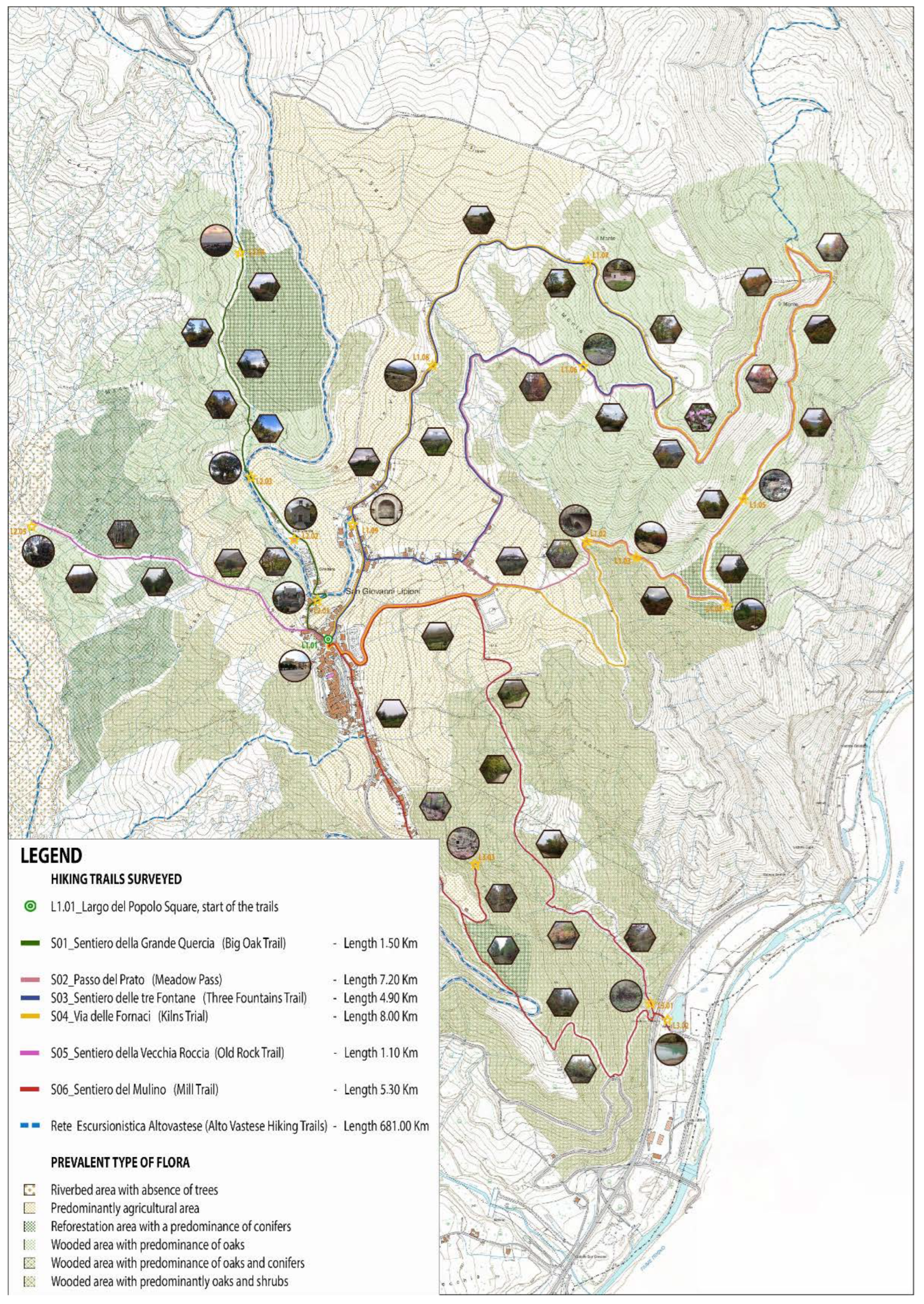
Rete Sentieristica Alto Vastese (Alto Vastese Trail System) and extends over approximately 681 km (
Figure 2). The present article deals with refunctioning the main paths within the municipal territory of San Giovanni Lipioni, with a total development of approximately 32 km.
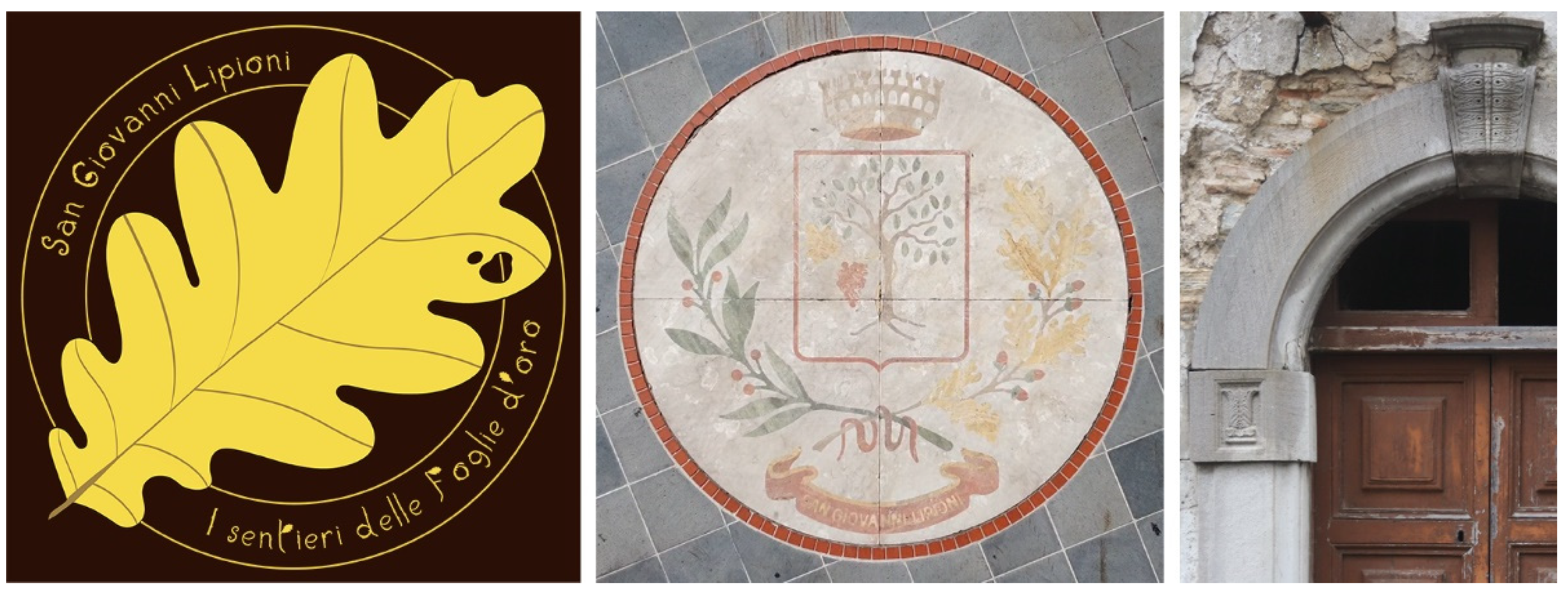
Often, the choice of the name for a path system has great importance because of a tourism promotion project. For the San Giovanni Lipioni trails, a name and logo could be, on the one hand, intimately connected with the community and the territory and, on the other hand, could have a distinctive and iconic character because of a future web diffusion. Therefore, this research coined the naming of the Sentieri delle Foglie d’Oro (The Golden Leaves Paths) which employs a leaf of the same color as an icon. Consequently, the same oak-leaf-themed font employed in the logo is used to characterize maps and texts inside the signage. This choice was inspired by the characteristic leaf of the Roverella oak tree that covers most of the woods surrounding the village; during the autumn season it lets the hills shine in all shades of gold, from yellow to brown.
This symbol is widely diffused in the architectural and cultural heritage of the village. Indeed, the gold leaf is not only present within the municipal coat of arms but is also recurrent as decoration on the keystone and imposts of many stone portals in the building’s historic center (
Figure 3).
Recreational trails are often classified according to the type of activity that can be practiced on them, such as hiking, backpacking, horseback riding, mountain biking, driving off-road vehicles, etc. [
52,
53]. Another subdivision can be made according to geographical location or the type of landscape, presence of national parks, forests, deserts, etc. [
54,
55]. In Italy, there is no national regulatory framework for pathways requirements to allow bicycle, pack animal, or pedestrian traffic [
55]. For this reason, it is necessary to refer to regional regulations and the CAI (
Club Alpino Italiano) as the only unifying agency to avoid slight differences between different locations. Several laws have been issued concerning hiking trails in the Abruzzo region, where San Giovanni Lipioni is located, but they do not provide stringent technical recommendations [
56,
57]. As with other Italian contexts, Swiss regulations are often the reference of CAI manuals and provide several indications for planners [
58,
59,
60]. Concerning the San Giovanni Lipioni footpaths reactivation project, the trail gradient, the road pavement, and reduced width allow only the transit for walking and hiking while not being entirely safe for bicycles. Moreover, a cycle path would require more maintenance, where monitoring and handling are crucial for its long-term sustainability [
61].
However, taking into account the indications of the Italian and Swiss Tourist Club [
58,
62], the paths do not have a high degree of difficulty; in fact, many trails around the village are on asphalted roads, although there are steep slopes or very narrow sections in the forest segments that classify them as tourism itineraries or hiking trails. Tourism itineraries are defined as mule tracks and ancient communication routes near villages, characterized by an accessible difficulty degree, suitable for cultural and recreational walks, while hiking trails are defined as paths without technical difficulties, mostly corresponding to mule tracks built for agricultural or pastoral purposes or connecting to mountain shelters. They account for about 75% of Italian routes. Moreover, since the maximum walking time is always within a day, they can all be considered short-distance routes [
58].
The methodology herein proposed is divided into different phases: (i) the digital survey using GPS receivers and outdoor navigation apps to outline the historical paths, in the meantime, shooting and filming are performed using drones and action cameras; (ii) the creation of a web platform with a system of virtual itineraries between the small villages that brings you into the natural context and makes you discover the most iconic places for social networks; (iii) analysis of the specific territorial features and natural resources surrounding the trails, identification of points of interest, evaluation of the conservation state, and operations necessary for trails reactivation, such as trimming of branches and vegetation, drainage interventions, repairing of the existing paving, maintenance of landslides, etc.; (iv) the design of iconic trail signs with artistic illustrations used both for wayfinding and to highlight points of interest with storytelling and helpful/interesting information, based on the historical memory steeped in ancient tales of the country’s peasant lifetime.
First of all, the dualism between digital surveying and mapping employs the currently available digital technologies as the primary tool to conduct a comprehensive analysis of areas in order to promote tourism development, allowing for the planning and virtual tour of the village trail system [
63]. Secondly, it allows for the scheduling of reactivation works, prioritizing them based on available resources. Indeed, some paths are already substantially accessible by future hikers and require only ordinary maintenance works such as pruning and trimming vegetation. In contrast, other routes require significant actions such as restoring the roadbed to ensure proper drainage and repairing dry stone walls. Therefore, the research results aim to provide possible useful indications for the organizations that will handle trail restoration, as well as define digital dissemination as the main promotion way to make small communities known worldwide. Indeed, paths, mule tracks, and dirt ruts played an essential connecting role between small settlements, surrounding farmlands and the grazing areas, constituting a capillary presence in the territory that has been progressively abandoned since the 1950s. Nowadays, the reuse of these routes represents not only an opportunity for tourism development but also a way to save this aspect of local historical memory [
58].
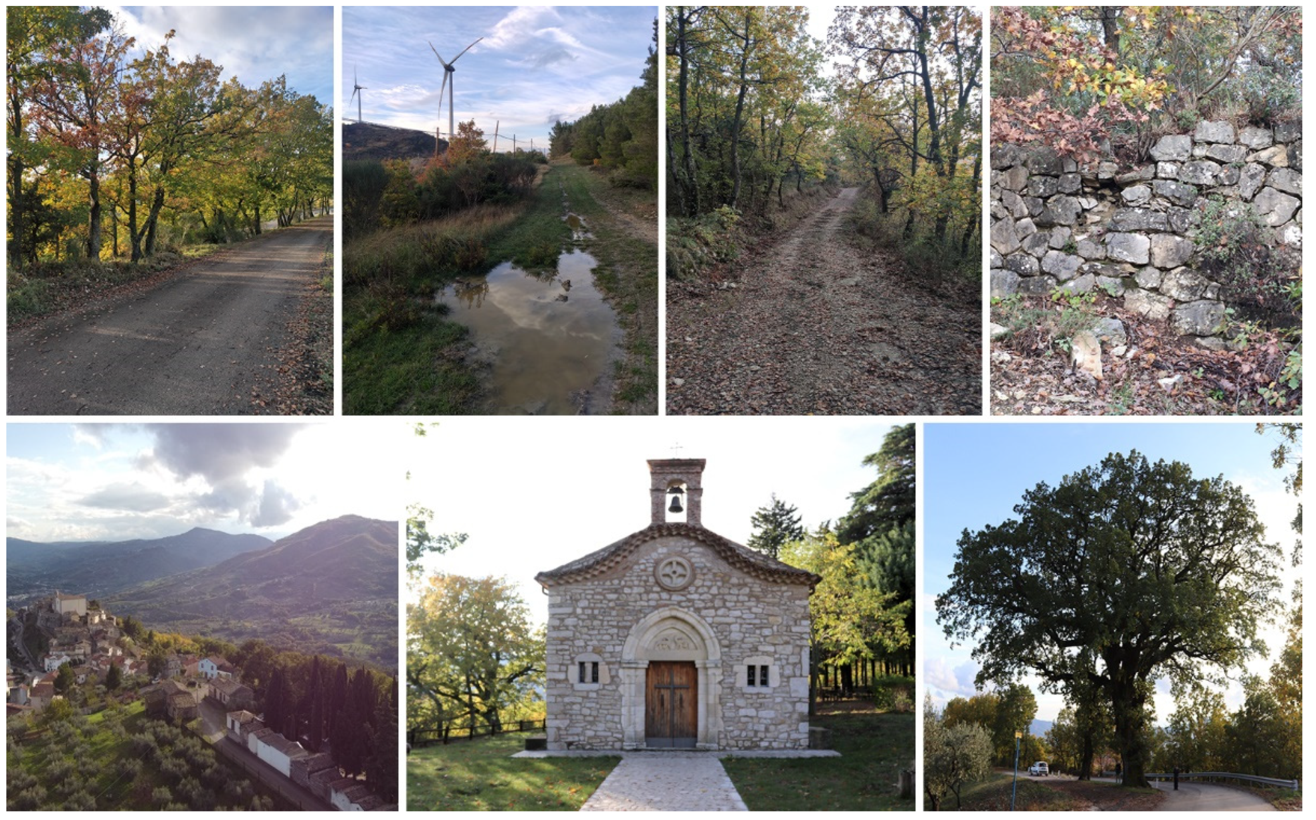
The photographic and video survey (
Figure 4) was conducted using an action-cam GoPro Hero 9 Black, characterized by 20 MP sensor and 5 K video with HyperSmooth 3.0 video stabilization, and a DJI Mavic Mini, an open category UAV of C0-class identification label (MTOM < 250 g) 1/2.3” CMOS sensor with 12 MP effective pixels, images of 4000 × 2250 pixels. The trails survey was carried out using handheld GPS, Garmin Etrex 32×, characterized by employing GPS and GLONASS satellite systems, a three-axis compass, and a barometric altimeter, and two mobile applications for navigation and route planning, Wikiloc
® and Komoot
®, installed on two different cell phones.
This instrumentation was used to collect different types of data for two primary purposes (
Figure 5): (i) first of all, to create a system of virtual itineraries that allows complete immersion in the village context, accessible through web platforms. For this purpose, the use of handheld GPSs allows georeferenced data on trails, such as overall length, elevation, and duration. In addition, information on cultural and natural heritage (points of interest) is punctually identified along the route in an accurate manner through the use of waypoints. This heritage is documented by shooting and filming using drones and action cameras; (ii) to punctually record accurate information on the maintenance state and signage required along the routes in order to provide intervention guidelines for refunctionalization operations.
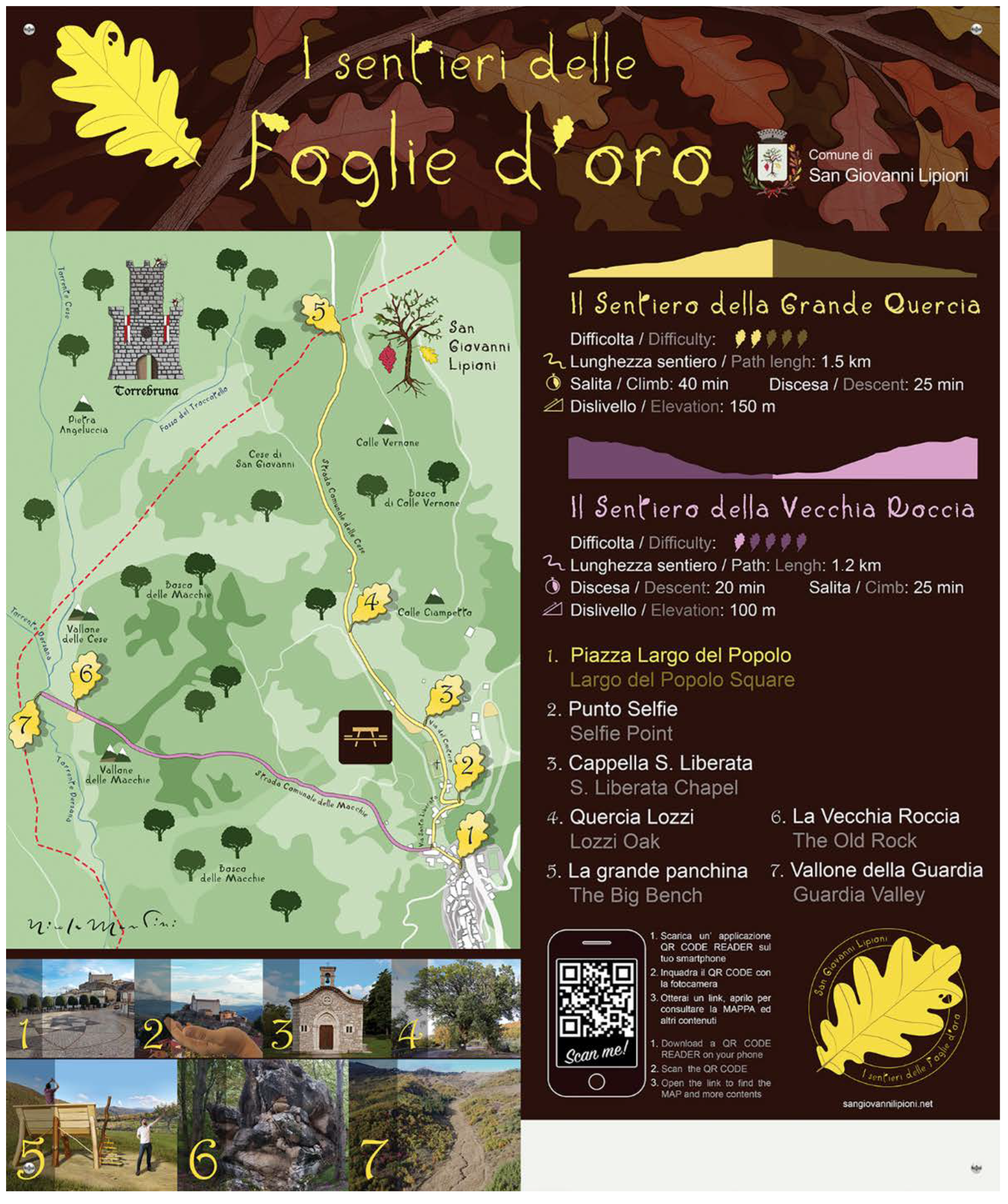
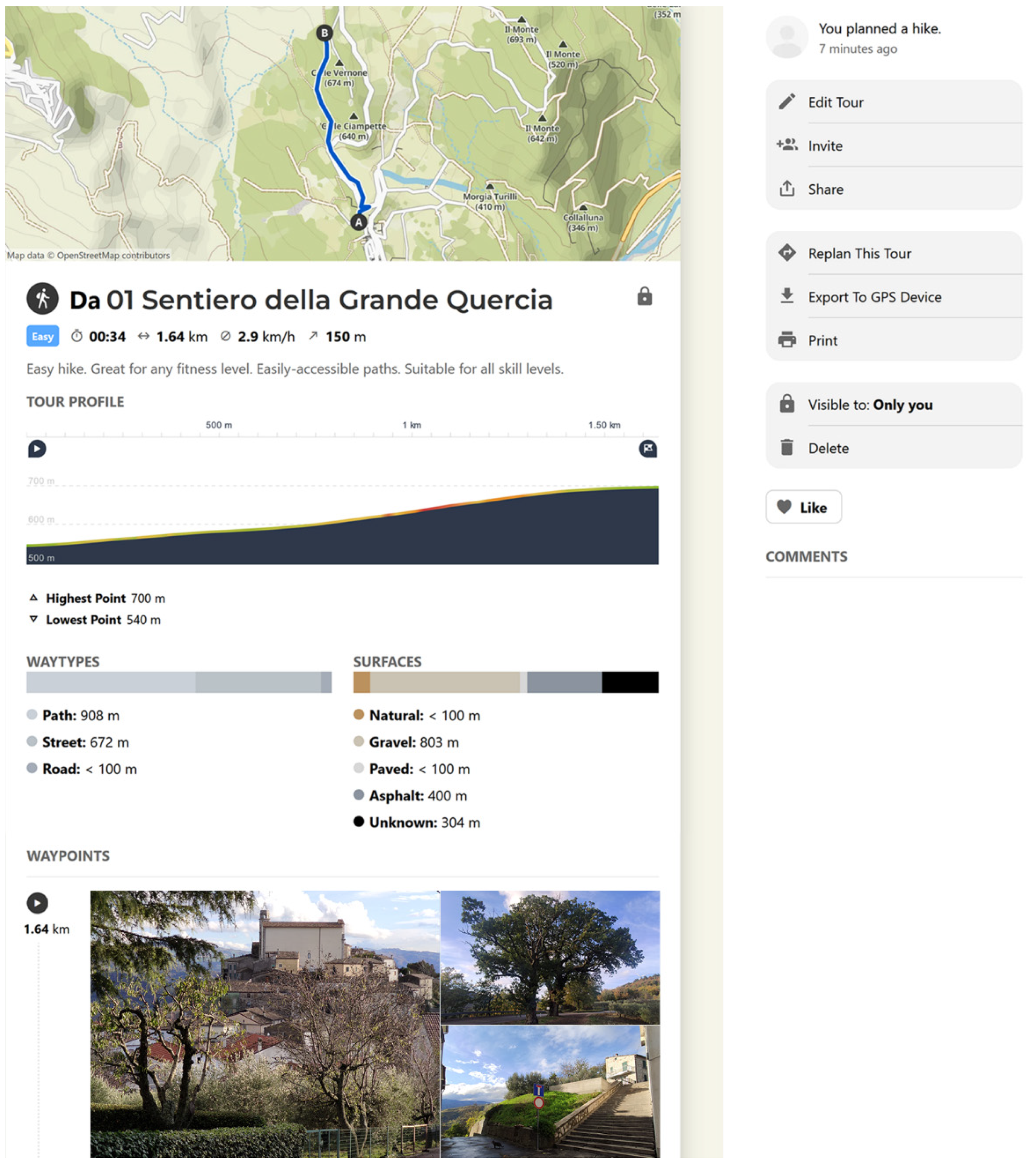
An alphanumeric code and an evocative name referring to the main attributes along the route identify each trail. In total, six paths have been identified, referring to three significant circuits: S01_Big Oak Trail (Sentiero della Grande Quercia): 1.50 km in length and 1:20 h in duration, and S05_Old Rock Trail (Il Sentiero della Vecchia Roccia): 1.10 km in length and 0:40 h in duration, belonging to the circuit that connects Torrebruna and Guardiabruna, through a wooded area characterized by the presence of a creek and oaks;
S02_Meadow Pass (Il Passo del Prato): 7.20 km in length and 2.30 h in duration, S03_Three Fountains Trail (Il Sentiero delle Fontane): 4.90 km in length and 1.40 h in duration, and S04_Kilns Trail (Via delle Fornaci): 8.00 km in length and 2:50 hours in duration, forming a ring in the wood to the northeast of the village in the direction of Celenza sul Trigno, in the area characterized by the most significant prevalence of historical traces linked to agricultural, pastoral, and craft activities; finally, S06_Mill Trail (Sentiero del Mulino): 5.30 km in length and 1.40 h in duration, heading south of the village through a steep ancient entrance path to the village, in the direction of the river Trigno and Roccavivara. Moreover, the rediscovery of the four historic stairways of the village was among the project’s purposes. In particular, the two within urban fabrics are widely known and popular, while the last two are isolated in the surrounding woods, whose traces had been lost over the decades.
The natural heritage of San Giovanni Lipioni was classified with particular attention in order to enhance and protect it. This analysis was conducted on specific thematic maps containing information on the prevalent types of tree species present along the paths. Indeed, the village presents a great variety of landscapes. In the area surrounding the urban fabrics, the land is mainly occupied by farming, olive crops, and fields left for pastures; moving westwards along the Vallone della Guardia creek, a reforestation area was created by planting mainly conifers, borders with a zone of oaks and shrubs until reaching the river area, where only bushes and shrubs are present; the zone to the north towards the village of Torrebruna is occupied by a dense forest of oaks, the most characteristic tree in the region until reaching an area where conifers begin to coexist; the area to the east and south is the most varied, changing from agricultural landscapes to oak woodland with the coexistence of different species, including the wild cyclamen used to make the flower crowns of the main village festival.
3. Results
The reactivation proposal of the San Giovanni Lipioni Trail System is part of the larger project concerning the Alto Vastese Hiking Trail System, which counts 48 footpaths covering 321 km and cycle paths of 360 km for a total of 681 km. This project proposes to develop a common strategy and systematize resources and attractions present in the area, in nature, cultural, enogastronomic, and traditional terms, through the involvement of local communities and stakeholders to obtain a single system of use, management, promotion, and tourist accommodation.
In order to activate a project on this scale, to act through tourism web promotion is nowadays indispensable, allowing people to form imagery of the places they will visit, and it is also important to act on a territorial level in order to meet these expectations and strengthen this relationship between tourism and landscape. Many research activities confirm that commercial logic is the main architect in promoting the peculiarities of places, forming real imagery over time [
63] and then spreading spontaneously through social networks, which is still different from the objects and landscape actually seen [
64]. Therefore, it is essential for this imagery to be formed not only by the surrounding natural landscape but also based on the local communities that could both minimize possible interferences with the cultural heritage and integrate the new groups of people with the local customs, traditions, and way of life, creating the so-called “lived landscape” [
37]. Hence, these initiatives are related to the tourism industry based on the understanding of places and respect for cultural heritage. Sustainable tourism policies should guide economic operators and stakeholders to enhance local identity in the landscape so that environmental and human values are bounded and preserved through tourism [
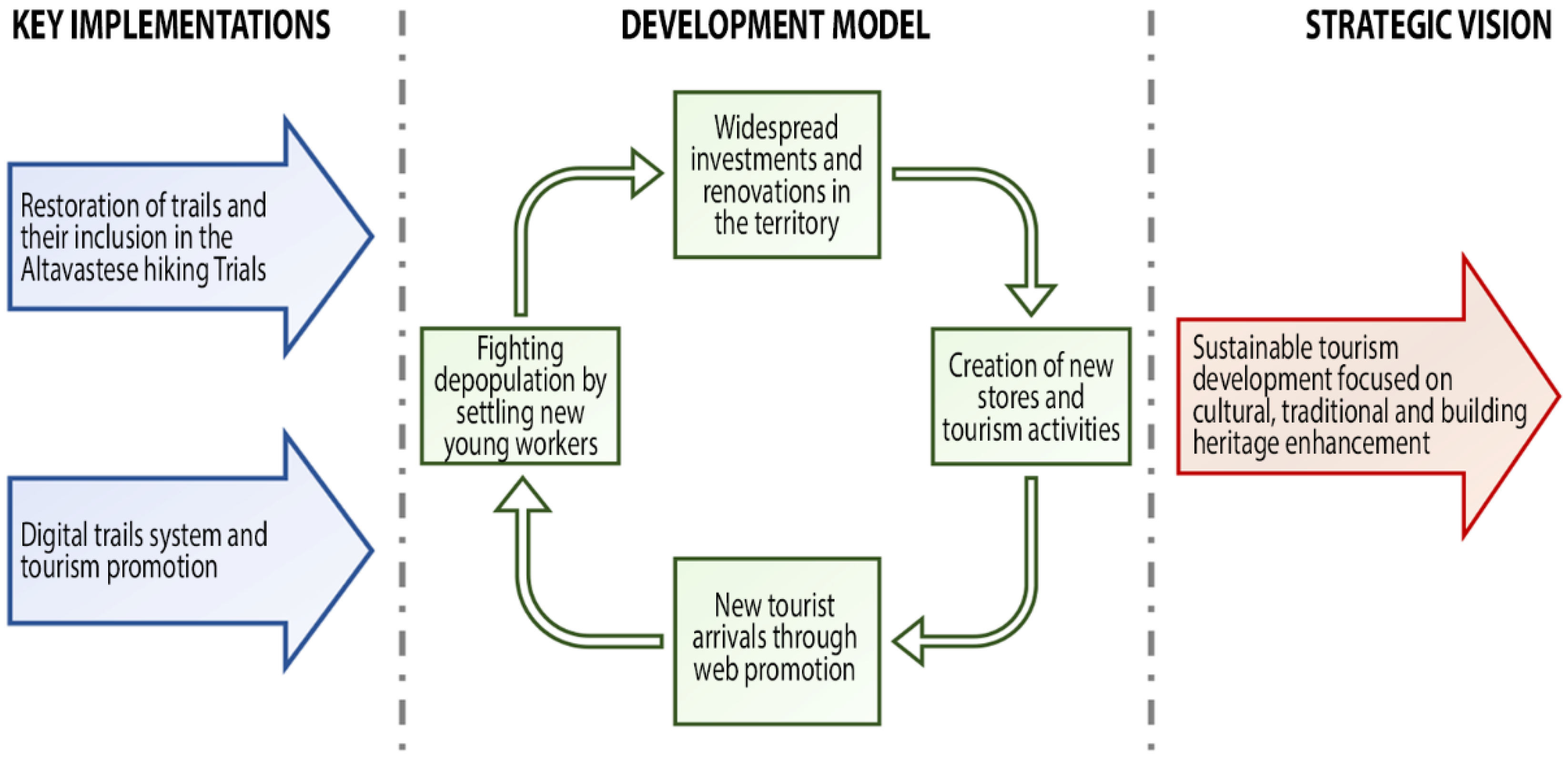
65]. If acting in this way prevents harmful effects on the environment and increases tourism in the area, two other factors need to occur to establish this self-sustaining growth model in a virtuous and synergetic way: the creation of tourism-related jobs and the settlement of new inhabitants [
66] (
Figure 6).
Refunctioning the municipal path system in synergy with a larger one, such as the Alto Vastese Trail System, affects the attractiveness of all the villages involved, both from an architectural point of view, with the reuse of buildings, and from a commercial point of view, with the opening of small shops or craft laboratories, and also from an agricultural point of view, with the creation of agritourism and other related activities, thus directly counteracting the phenomenon of depopulation [
67,
68]. Two key points are the basis for implementing the strategic vision of sustainable tourism development focused on cultural, traditional, and building heritage: (i) the development of a digital trail system included in the broader programme of the Alto Vastese Hiking Trials (“
Rete Sentieristica Alto Vastese”); (ii) the suggestion of recommendation operations and design of touristic signage to reactivate the paths. These two factors are linked by the communication strategy and the common graphic language used on the website and signage. The Golden Leaves Paths are organized as a complementary part of the Alto Vastese Trail System, which means that it retains completeness along a ring route even separately. The cluster structure allows the nonsimultaneous potential start of works within the different municipalities independently. The Golden Leaves Paths are designed to have a common starting point in the main village square, where all general signs are placed and branch off in various directions in continuity with the Alto Vastese Trail System.
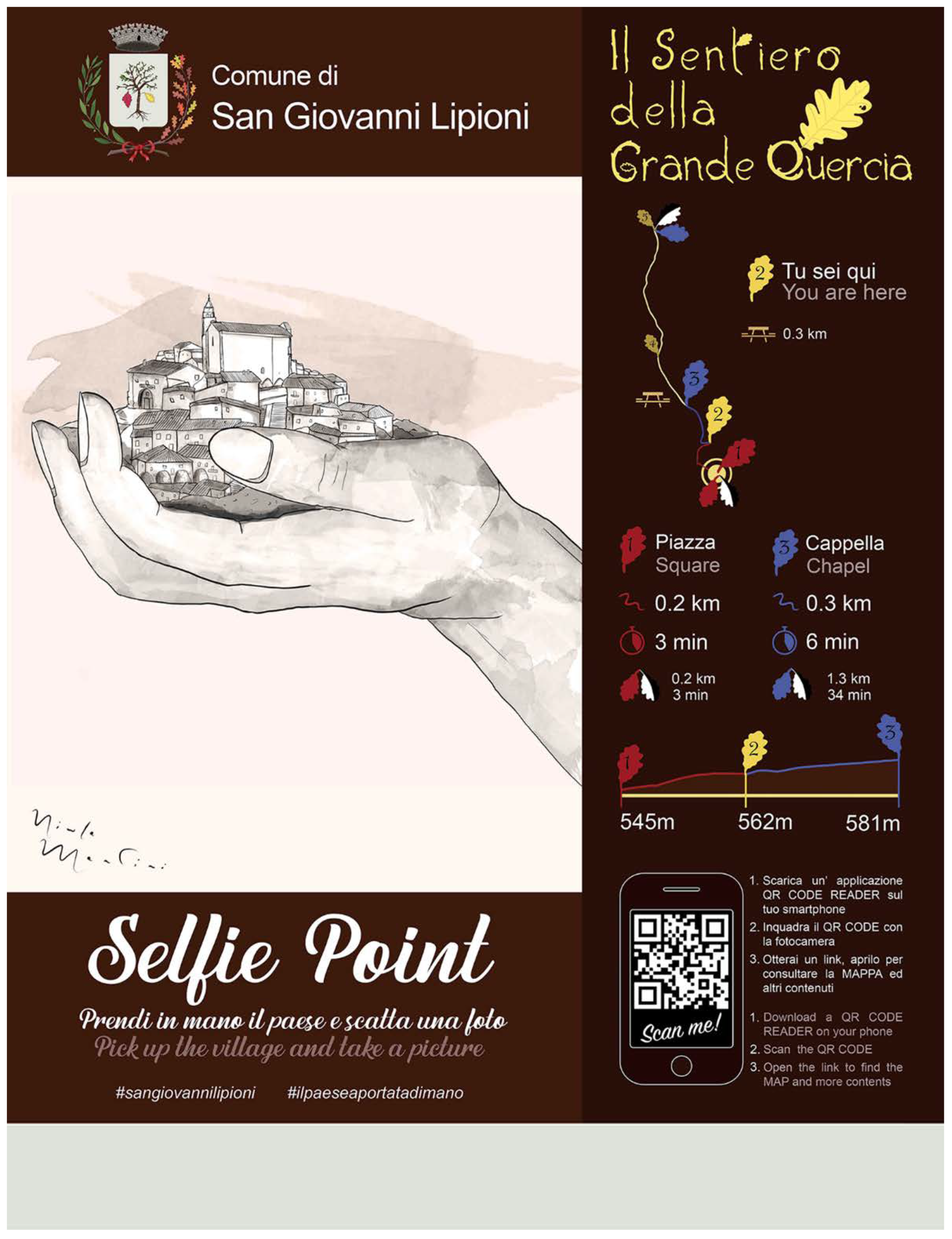
For each of the circuits, a general sign is provided to indicate (i) the paths included in the ring route, and for each one, the primary information, such as difficulty, length, ascent time, descent time, and the overall height difference. In addition, different points of interest encountered along the way are listed and correlated with photographs (
Figure 7); (ii) at the bottom, there is a QR code link to multimedia content associated with the tourist promotion site of the trails, which refers to in-depth information concerning, on the one hand, points of interest encountered along the route, such as architectural elements (for example, fountains or chapels), panoramic viewpoints, or the natural heritage, and, on the other hand, distinct components of the local intangible cultural heritage, such as the history and memory of the village, the current festivities, or the ancient craftsmanship now lost, for example, lime or brick production in furnaces (“pinciere”). Each point of interest listed in the general signage is associated with a specific sign along the route characterized by an artistic illustration with similar graphics based on the inhabitants’ historical memory. Consequently, the concise description list below this type of sign (
Figure 7) is based on the immaterial legacy rather than the current situation, with the opportunity to deepen knowledge via QR code for further detailed information, images, and historical photographs. In addition, the graphic chart indicates the user’s relative position compared to the start and beginning of the route and the distance and time to the previous and next point of interest.
The oak leaves theme was chosen as the leitmotif of the route signage graphics for both the maps and points of interest (
Figures S6–S13). The background color recalls brown shades typically used in Italy in tourist signage. In contrast, brighter and more primary colors characterize the realistic and stylized graphics of maps and illustrations in order to provide a simple, clean, and modern design.
In parallel, the same graphics language is employed for the digital website of routes, designed as a primary way to promote the tourist trails system worldwide and to host multimedia information related to the sign QR codes. In order to create shared collective imagery of the routes, the digital exploration of trails constitutes the first step on which to build subsequent physical experiences by the tourist. Consequently, the iconic choice of names, graphics, and symbologies become part of the strategy to promote an image of the village community to the outside world (
Figure 8).
The presentation of apparently simple places should be focused on enhancing the peculiarities of their ancient and rich traditions as part of a touristic experience rooted in the rediscovering of the intangible culture of a specific place, instead of merely as a presentation of virtual itineraries, although set in a high-landscape-value area [
69].
Moreover, as in many examples, virtual promotion becomes an opportunity to sponsor village events and initiatives for the wider community [
70,
71]. In this perspective, social networks play a decisive role in conveying information thanks to user sharing. Consequently, envisaging and promoting places suitable for social media sharing along trails becomes an essential aspect of the design of points of interest. As an example, the Selfie Point sign proposal (
Figure 8) suggests an evocative way to take a photo with the shape of the hand encircling the village, accompanied by the hashtag
#ilpaeseaportatadimano, which recalls the Italian expression “
a portata di mano”, used to indicate something easy to reach, as a metaphor of the small village, enclosed within its paths in antithesis to the stressful world from which visitors seek refuge [
38].
The tracking activity was designed to be disseminated on the main hiking sites and applications widespread in the territory, such as Komoot
® and Wikiloc
® (
Figure 9), also used during the survey campaign to collect photos and video data concerning points of interest and the conservation state.
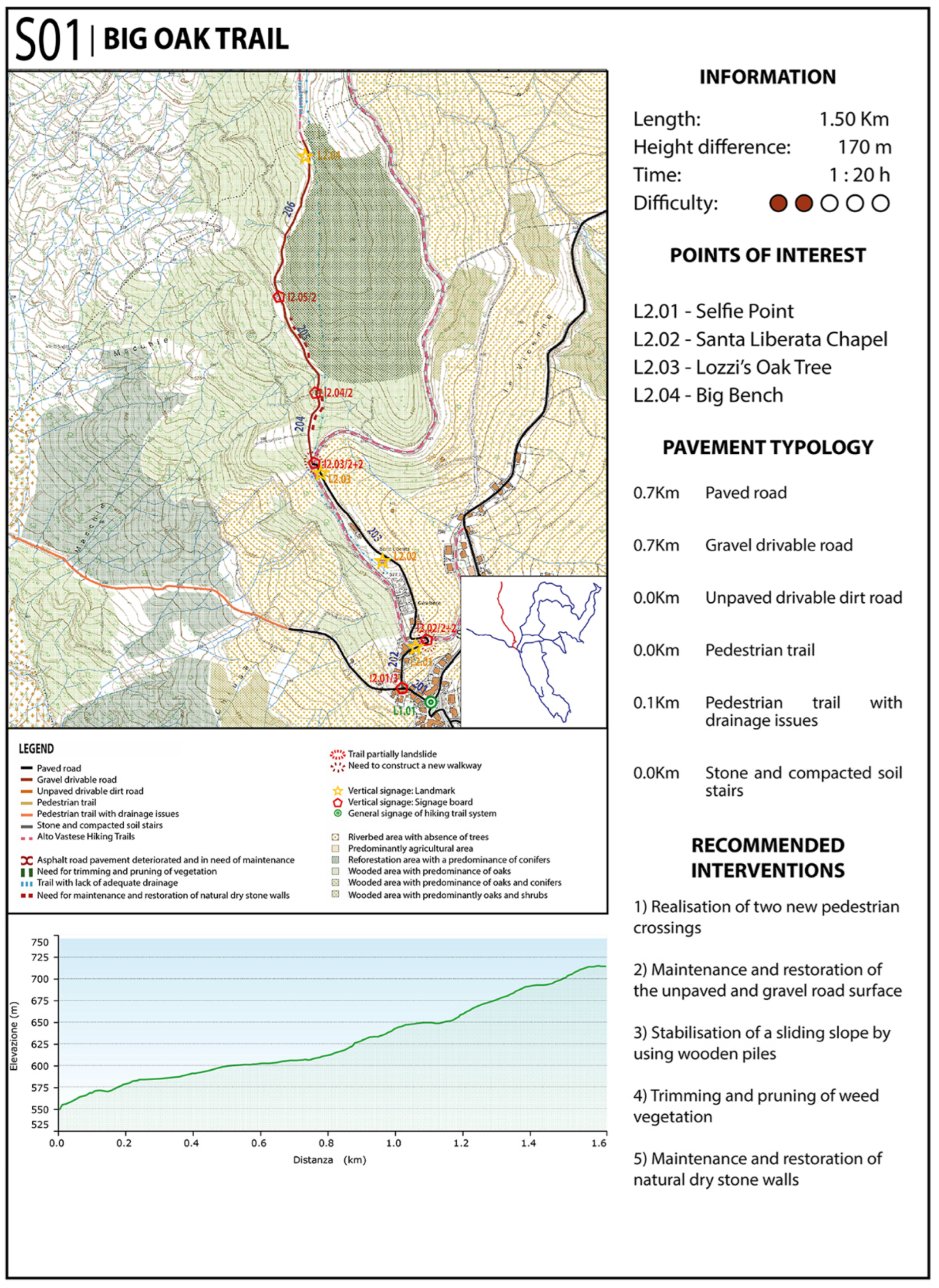
Nevertheless, employing .gpx trail files allows operating independently of platforms, making web dissemination easier and broader. To obtain a complete mapping of the conservation state, each trail was analyzed section by section, indicating the pavement type, the variety of flora species, and the presence of criticalities or peculiarities. First of all, a progressive numerical code was employed to classify each section uniquely. The first digit indicates the circuit of the trail, while the other two follow the progressive numbering, starting with one. Sections thus identified are obtained by subdividing the GPS track from crossroad to crossroad into many elements of variable length; consequently, the same criteria were applied to classify each direction sign uniquely, employing an alphanumeric code where the first letter is associated with sign typologies, the first digit indicates the circuit of the trail, and the other two follow the progressive numbering, starting from the main path. In addition, a second digit separated by a slash character indicates the number of direction sign required to give road information in accordance with CAI guidelines [
58]. This number can be composed of one or two digits depending on whether the trail is planned autonomously or associated with the Alto Vastese Hiking System; the points of interest follow a similar logic to the previous classification, using an alphanumeric code composed of a digit associated with the path and a progressive numbering to indicate the various places. Detailed classification is also used to obtain a simple and precise reference for all the signage required to activate the trail. Signage herein assumed in the reactivation scenario is based on the detailed and precise indications provided by CAI in terms of materials, dimensions, and color of elements: directional, locality, and other vertical signage follow exact geometric dimensions, as well as font size and character defined and coloring identified with RAL codes [
72]. Regarding several materials, the choice is guided by a view to durability and cost; despite the signage of points of interest being independent of CAI indications, the option is more flexible. It was nevertheless considered to make it as similar as possible in terms of materials and design to optimize cost-effectiveness and minimize the visual pollution caused by the copresence of many different signage types on the same route. For these reasons, larch represents a good balance between durability and low-maintenance needs to integrate the signage in the surrounding landscape. On the other hand, point-of-interest signage requires a rich graphic printing; hence, panels made of closed-cell, semi-expanded Forex PVC were evaluated to take full advantage of material properties such as easily printable surface, inexpensively, durability, recyclable, and zero maintenance cost, although they had relative fragility [
72].
The conservation state analysis of paths and the section-by-section classification based on materials and construction technique of pavement surfaces assume particular importance in order to indicate recommended categories of intervention for each case, based on the CAI guidelines for Italian paths (
Figure 10) [
73]. First of all, it should be noted how a path’s correct use in correlation with the road surface is fundamental to guarantee its durability. Indeed, it is widely recognized that the improper use of pedestrian paths can be responsible for many damages, and in some cases, safety is compromised due to insufficiently hard ground. In this regard, routes are considered suitable for mountain bike use, where it is possible to pass both ways at the same time or on specifically approved sections [
72].
Regarding San Giovanni Lipioni, different pavement types were identified, depending on the routes and proximity to the urban center. All the initial sections of the trails, which begin in the village’s main square and develop into peripheral roads, are paved roads for a total of 12.30 km. These paved roads are almost wide enough to allow the passage of two vehicles in opposite directions. The bituminous road surface is currently stable and in good condition without any deep potholes, unevenness, or dips due to vehicular traffic that could pose a risk to trail users. For this pavement typology, the only recommended works are ordinary maintenance and repairing a few damaged sections. Subsequently, the major categories are drivable gravel roads, 6.00 km in length, and unpaved drivable dirt roads, 1.30 km. These two types are often present in successive sections of the same path. The path has a dirt road surface with gravel or simple compacted soil of sufficient width and compactness to make it passable for agricultural vehicular traffic. For the muddy sections without proper water outflow and where the road surface has significant dips due to vehicular traffic, it is recommended to restore the path and ensure its durability and resistance by using one or two layers of granular material with different grain sizes.
There are also numerous kilometers of pedestrian trails (7.20 km), which are 1.60 km with drainage issues, characterized by compacted dirt surfaces and dimensions unsuitable for vehicular traffic. These types of pavement often present widespread water stagnation problems due to the lack of rainwater outflow. In addition, in this case, recommended interventions are similar to the previous ones. Finally, about a hundred meters are constituted of stone and compacted soil stairs, ancient access roads to the village. In addition, the various critical points along the routes were marked, such as relevant operations of pruning trees and cleaning up the weeds, the need for restoration and maintenance of drystone retaining walls, and the implementation of pedestrian crossings in correspondence with busy and dangerous driveways. With regard to regular maintenance works, cutting intrusive vegetation flush with the edge is recommended along entire trails, particularly for thorny species such as brambles, while preserving trees and shrubs that improve shading as much as possible. Recommended works for retaining stone walls depend on the conservation state: (i) for sections without out-of-plumb issues, only cleaning and maintenance operations should be carried out to guarantee their durability, with specific attention paid in the case of walls higher than 1.5 m due to the danger of partial collapse; (ii) for sections with out-of-plumb or partially collapsed walls, partial demolition of compromised parts and subsequent reconstruction using traditional techniques is recommended, with particular consideration to the reuse of stone blocks for the subsequent joining between new and old parts of masonry. Regarding pedestrian crossings, a solution in line with the graphics used for the web promotion of the tourist trail system and signposting is devised to solve the problem of poor visibility (
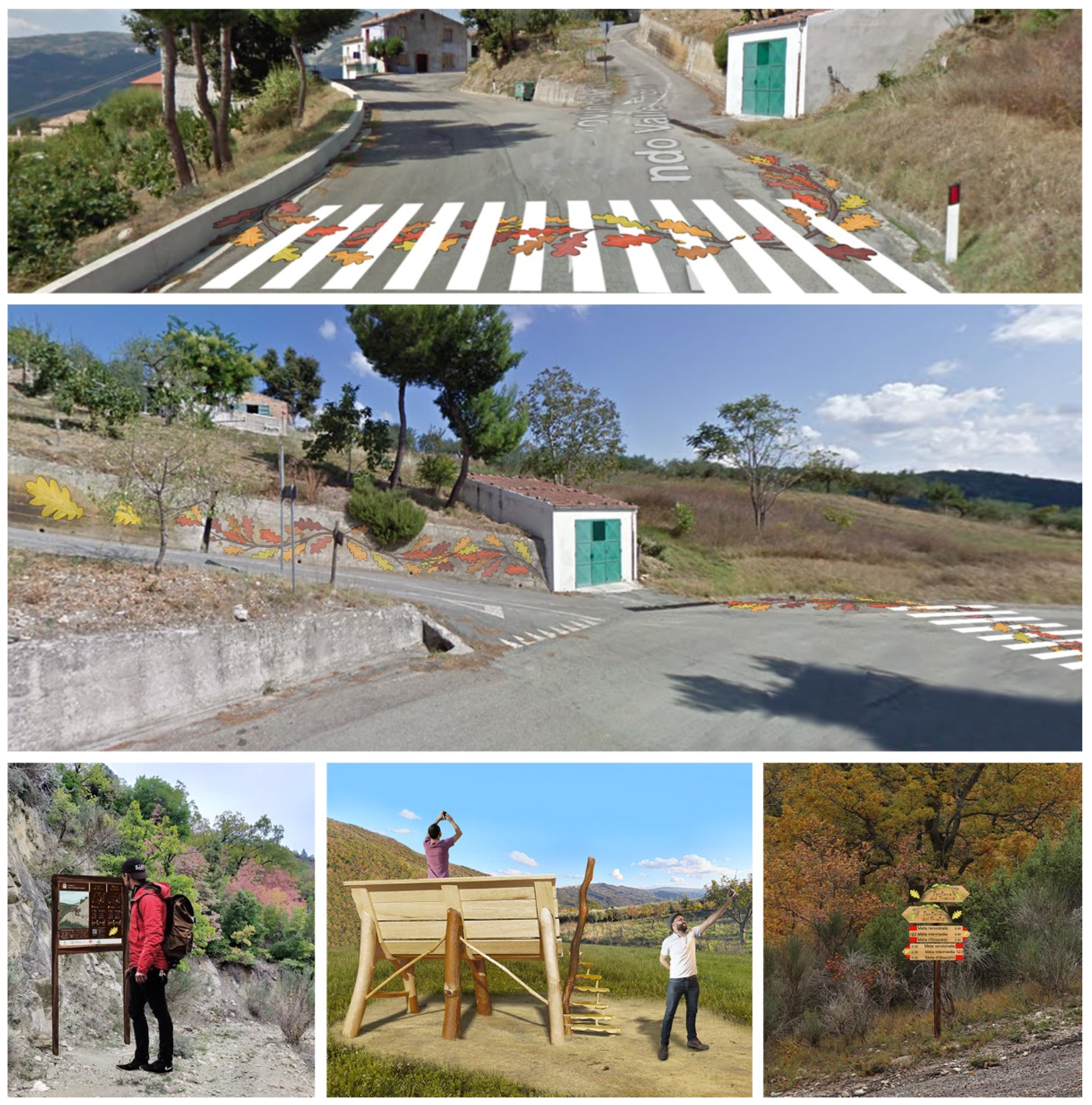
Figure 11).
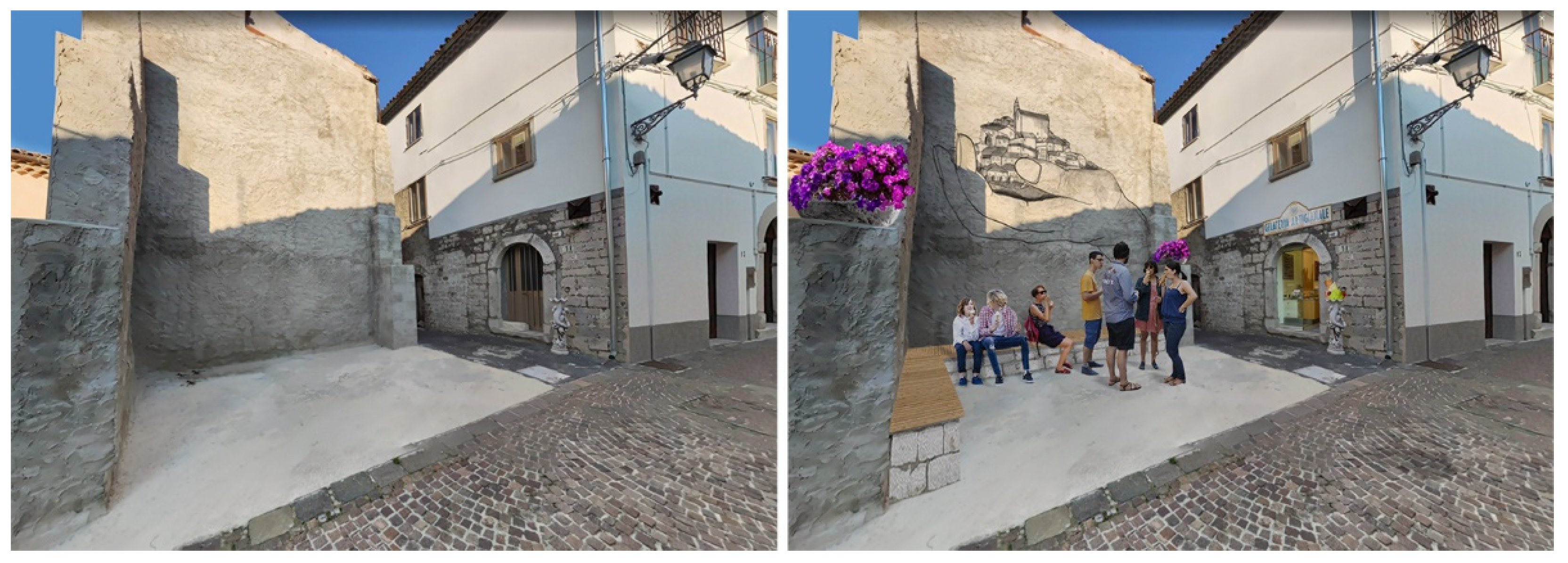
The gold leaf is used directly to shape the territory’s image, becoming, in this case, a way to highlight the crossings using bright colors in order to induce greater caution and reduced speed in anticipation of possible passage of hikers. Graphical references to paths’ signage language are also employed in some intervention proposals on the built heritage, for example, creating a small square next to the village church and reusing adjacent buildings for commercial activities (
Figure 12).
In the same image (
Figure 11), other intervention proposals with the leitmotif of the oak leaf are provided: (i) the installation of point-of-interest signage along a path; (ii) the design of a big bench in the shape of the leaf, positioned in a panoramic place to enjoy beautiful views of the surrounding countryside.
This analysis was carried out section by section on all the paths surveyed, and the results were summarized in concise factsheets (
Figures S1–S5).
4. Discussion
The case study shows the initial stages of a developing sustainable tourism initiative based on implementing a digital and territorial trails system to enhance cultural and natural heritage in the rural area of San Giovanni Lipioni, Abruzzo, Italy. The valorization proposal takes place under a broader regional project involving many similar villages in order to reactivate a set of ancient agricultural and pastoral routes, called Alto Vastese Trails System (“Rete Sentieristica Alto Vastese”). The project is located in a hilly inland rural area of the Abruzzo region, characterized, on the one hand, by being still exceptionally intact in terms of landscape and, on the other, for being geographically close to two of Italy’s major cities, Rome and Naples; thus, it is particularly suitable for a nature tourism vocation.
The research paper was developed on two levels. The first consists of the critical–interpretative level, which starts from studying the challenges and potentials of inner areas and, through the analysis of the theoretical background, identifies the opportunities for initiating a sustainable tourism development process. The second operational level concerns the work necessary to reactivate the routes and shows the main phases of the tracking and surveying campaign, describing the subsequent analysis of data in order to introduce the intervention proposal that consists of the design of tourism promotional signage and the necessary maintenances and restoration operations on the paths.
In the first part, the research aims to describe the conditions that led to the depopulation of inner areas, in particular analyzing the role that the lacking post-war industrial development played in this phenomenon. Subsequently, the theoretical background is analyzed to evaluate the potential economic benefits brought about by the activation of sustainable tourism in similar virgin naturalistic contexts. In particular, sustainable tourism becomes an excellent opportunity for the rebirth and repopulation of these places both for job creation related to accommodation facilities and for all related commercial activities. In the second place, the sustainable development of inner areas could also attract people interested in remote work, distant from the stressful pace of big cities, and seeking a different lifestyle with the possibility of being outdoors and improved general welfare, resulting from the relationship with nature and genuine human relationships. To achieve this result, the process requires an in-depth analysis of the village’s territorial identity, in particular on the tangible and intangible local culture, enhancing the characteristics of uniqueness, beauty, and authenticity of the village. Consequently, the proposal methodology type in this research is particularly suited to certain precise contexts such as historic villages located in rural inland areas. Indeed, the historicity of places implies preserving a cultural and architectural heritage that becomes an attractive value towards tourism. This value should not only be considered as a material asset but also as intangible culture linked to ancient local traditions. Furthermore, on the one hand, being located in a remote area has led to a lack of economic development related to the industry; on the other hand, it has allowed maintaining an unspoilt natural landscape, which is increasingly rare in Western Europe. This characteristic is perfectly suited for natural tourism from nearby cities and international tourists.
The second part of the research outlines the strategy to start the reactivation of the trail system and criteria for tourism promotion through virtual itineraries. Through the use of cameras, drones, and handheld GPS receivers, the survey campaign allows obtaining all the information to define necessary reactivation interventions and disseminate promotional materials for tourism development. A thorough analysis of the trail maintenance state allows for promptly detecting interventions needed along routes to direct funds and prioritize actions. In parallel, the collected tracks are employed to build the digital trail system, which is designed to be shared on websites and main trail applications to widely promote the routes, enhancing natural and cultural local heritage in the area with photos and videos. Signage with artistic illustrations characterizes the routes, giving information provided by local inhabitants to keep the historical memory alive. The golden leaf motif becomes a unifying element of the different phases, from the tourist’s imagination, realized with the suggestions of a bygone age and recovery of local traditions, to the digital promotion of trails that allows them to dive in and experience the places before discovering them in real life, and finally culminating in the direct experience of the tourist, who finds the landscape he had imagined before arriving empowering, and shares the idea that had attracted him before leaving on social networks. Social networks thus become a central aspect of the communication strategy, influencing the design of points of interest along trails by devising iconic elements that can recognize places through image-focused social sharing sites. The methodology herein proposed is designed to be realized involving local communities on the model proposed by CAI for its trail system. Although the research does not focus on an economic assessment of interventions, it should also be considered that a large part of interventions will be implemented with the help of local volunteers, significantly reducing costs according to available resources of a small rural village. Indeed, proposing an economically sustainable solution to indicate a simple manner of reactivation for nature tourism is a core aspect of counteracting depopulation issues in rural areas.
The strategy herein proposed is part of a larger regeneration and revitalization project of the village of San Giovanni Lipioni [
74]. The article outcomes are part of the documentation produced for a research contract with a local social promotion association that will use them to reactivate the trails from a nature-oriented tourism perspective. The technical documentation of surveyed paths, summarized in the concise factsheets (
Figures S1–S5) will be employed as a knowledge base to guide maintenance and restoration works; artistic signage will be installed along the routes to accompany tourists in their discovery of the village; finally, the implementation of the website with the virtual itineraries will become the gateway to connect this small reality with the outside world. Future scopes of the research will be the extension of the methodology to other case studies of the Alto Vastese Hiking Trail System or, more generally, the analysis of the possible social and economic benefits of nature-oriented tourism to a rural village affected by depopulation. The topic of tourism development should therefore be thought of with a broad and non-self-contained perspective. The economic growth should be synergized with creating new accommodation structures and commercial activities with direct consequences of producing new jobs and permanent inhabitants in rural areas. The opportunities provided by revitalization could also lead to the establishment of new professional skills related to the services offered to the new inhabitants and the possibility of remote working in less chaotic villages than in large cities. Such perspectives might appear to be wishful thinking, but this paper shows broad examples of small Italian towns that have efficiently reversed this negative trend thanks to similar or different initiatives. In this perspective, promotion, especially through social networks, plays a key role in helping to raise awareness of the opportunities the village offers, and its natural context, to a wider public.

 ,
, 


