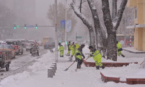
Low pressure developed across eastern China on Sunday, tracking across the northern coast of the Sea of Japan on Monday. On the west side of this low, an unseasonably cold air mass was drawn south across north-eastern China, resulting in a broad area of significant snowfall.
More than 30cm of snow is expected across higher parts of the Chinese provinces of Inner Mongolia, Jilin and Heilongjiang. Clear skies accompanying the widespread snow cover will lead to temperatures dropping significantly below normal on Tuesday.
For example, Shenyang is expected to experience subzero daytime temperatures, with nighttime temperatures falling to -12C, 10C below normal for the time of year. After a little respite as southerly winds return on Wednesday, high pressure is forecast to build southwards from Siberia across much of eastern China and neighbouring areas during the latter part of the week. This will lead to abnormally cold temperatures across a broad area, with parts of north-eastern China close to 20C below normal at times.
Central America felt the effects of Tropical Storm Pilar last week, which formed in the eastern Pacific south of Guatemala on 29 October. Pilar then drifted slowly eastwards, stalling close to the western coasts of Nicaragua, El Salvador and Honduras on 31 October. Heavy rain affected many parts of all three countries, with more than 100mm falling in some areas, leading to flash flooding and landslides, and reports of four deaths.
A cold front moving in from the north blocked Pilar from making landfall, with the storm instead turning back on itself on Wednesday. Strong south-westerly winds resulted in Pilar decaying late on Sunday, well to the south-west of Mexico.
Conditions remained unsettled across Central America during the weekend, as low pressure moved in from the east. There had been a small risk that this system could become organised enough to be classified as a tropical storm. However, the area of low pressure moved onshore before this could occur.
Despite this, parts of Honduras, Belize, Guatemala and the eastern tip of Mexico experienced heavy rainfall and intense thunderstorms. Heavy rainfall is expected to continue into the early part of this week, with parts of western Guatemala potentially receiving more than 300mm of rain.
